|
|
Antenna Structure Registration 1050833 |
 |
Registration Info | Registration Number: 1050833 |
| File Number: A1297417 |
| FAA Study: 98-AGL-1023-OE |
| FAA Issue Date: 05/06/1998 |
| Status: Constructed |
| Date Constructed: 01/01/1980 |
| FAA EMI: N |
| NEPA: N |
Structure Info
| Structure Type: TOWER |
| Structure Coordinates: 46-56-53.0 N 102-59-27.0 W (NAD 83) |
| Structure Coordinates: 46-56-53.0 N 102-59-25.4 W (Converted to NAD 27) |
| Structure Address: 11 Km N & .5 Km E |
| Structure City: South Heart, ND |
| Structure County: Stark County |
| Painting & Lighting Info |
FCC Paragraph(s): 1, 3, 5, 14, 21 |
Remarks: RED LIGHTS/PAINT. |
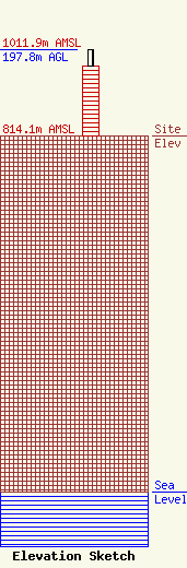
| Elevation Info |
Site Elevation: 814.1 meters (2671 ft) |
| Height of Structure: 158.5 meters (520 feet) |
| Overall Height Above Ground: 197.8 meters (649 feet) |
| Overall Height Above Mean Sea Level: 1011.9 meters (3320 feet) |
| Owner Info | Gray Local Media, Inc.
4370 Peachtree Road, NE
Atlanta, GA 30319
(404) 266-8333
legalnotices@graymedia.com |
| Contact Info | Gray Local Media, Inc.
4370 Peachtree Road NE
Atlanta, GA 30319
Engineering Department
(404) 266-8333
legalnotices@graymedia.com |
