|
|
Antenna Structure Registration 1050840 |
 |
Registration Info | Registration Number: 1050840 |
| File Number: A1297420 |
| FAA Study: 2019-AGL-18760-OE |
| FAA Issue Date: 12/10/2019 |
| Status: Constructed |
| Date Constructed: 11/17/2020 |
| NEPA: N |
Structure Info
| Structure Type: GTOWER |
| Structure Coordinates: 48-8-2.0 N 103-51-38.0 W (NAD 83) |
| Structure Coordinates: 48-08-01.9 N 103-51-36.3 W (Converted to NAD 27) |
| Structure Address: 19.3 Km West Of Williston, North Dakota |
| Structure City: Williston, ND |
| Structure County: Williams County |
| Painting & Lighting Info |
FCC Paragraph(s): 1, 3, 6, 15, 21 |
Remarks: PRIOR STUDY 1998-AGL-1892-OE |
Remarks: Continue As Is OM&L = PAINT/RED LIGHTS |
Remarks: PRIOR STUDY 1998-AGL-1892-OE |
Remarks: Continue As Is OM&L = PAINT/RED LIGHTS |
| Elevation Info |
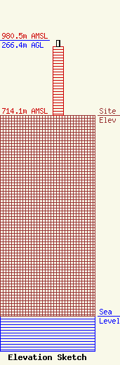
Site Elevation: 714.1 meters (2343 ft) |
| Height of Structure: 243.8 meters (800 feet) |
| Overall Height Above Ground: 266.4 meters (874 feet) |
| Overall Height Above Mean Sea Level: 980.5 meters (3217 feet) |
| Owner Info | Gray Local Media, Inc.
4370 Peachtree Road, NE
Atlanta, GA 30319
(404) 266-8333
legalnotices@graymedia.com |
| Contact Info | Gray Local Media, Inc.
4370 Peachtree Road NE
Atlanta, GA 30319
Engineering Department
(404) 266-8333
legalnotices@graymedia.com |
