|
|
Antenna Structure Registration 1051043 |
 |
Registration Info | Registration Number: 1051043 |
| File Number: A0060137 |
| FAA Study: 92-AWP-0055-OE |
| FAA Issue Date: 01/01/1992 |
| Status: Terminated |
| Date Constructed: 01/01/1992 |
| NEPA: N |
Structure Info
| Structure Type: TOWER |
| Structure Coordinates: 34-13-32.0 N 118-3-55.0 W (NAD 83) |
| Structure Coordinates: 34-13-32.0 N 118-03-51.8 W (Converted to NAD 27) |
| Structure Address: Mount Wilson |
| Structure City: Mount Wilson, CA |
| Structure County: Los Angeles County |
| Painting & Lighting Info |
| Elevation Info |
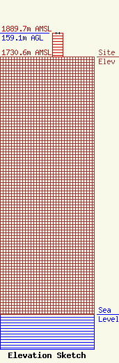
Site Elevation: 1730.6 meters (5678 ft) |
| Height of Structure: 159.1 meters (522 feet) |
| Overall Height Above Ground: 159.1 meters (522 feet) |
| Overall Height Above Mean Sea Level: 1889.7 meters (6200 feet) |
| Owner Info | AMERICAN TOWER SYSTEMS LP
1220 BRICKYARD COVE RD STE 200
PORT RICHMOND, CA 94801
(510) 236-3700
|
