|
|
Antenna Structure Registration 1051050 |
 |
Registration Info | Registration Number: 1051050 |
| File Number: A0822310 |
| FAA Study: 2013-AWP-45-OE |
| FAA Issue Date: 01/17/2013 |
| Status: Constructed |
| Date Constructed: 10/02/2001 |
| FAA EMI: N |
| NEPA: N |
Structure Info
| Structure Type: MTOWER |
| Structure Coordinates: 37-55-43.2 N 122-35-15.3 W (NAD 83) |
| Structure Coordinates: 37-55-43.5 N 122-35-11.4 W (Converted to NAD 27) |
| Structure Address: 2001 Ridgecrest Blvd (mt. Tamalpais T1 #8521) |
| Structure City: Fairfax, CA |
| Structure County: Marin County |
| Painting & Lighting Info |
FAA Chapters: NONE |
Remarks: PRIOR STUDY 2012-AWP-296-OE |
| Elevation Info |
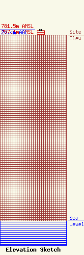
Site Elevation: 757.1 meters (2484 ft) |
| Height of Structure: 18 meters (59 feet) |
| Overall Height Above Ground: 24.4 meters (80 feet) |
| Overall Height Above Mean Sea Level: 781.5 meters (2564 feet) |
| Owner Info | American Towers LLC
10 Presidential Way
Woburn, MA 01801
(678) 564-3236
faa-fcc@americantower.com |
| Contact Info | American Towers, LLC.
10 Presidential Way
Woburn, MA 01801
(678) 564-3236
faa-fcc@americantower.com |
