|
|
Antenna Structure Registration 1051098 |
 |
Registration Info | Registration Number: 1051098 |
| File Number: A0507618 |
| FAA Study: 97-AGL-5898-OE |
| FAA Issue Date: 02/11/1998 |
| Status: Constructed |
| Date Constructed: 01/01/1997 |
| FAA EMI: N |
| NEPA: N |
Structure Info
| Structure Type: TOWER |
| Structure Coordinates: 45-58-32.0 N 89-14-44.0 W (NAD 83) |
| Structure Coordinates: 45-58-32.2 N 89-14-43.5 W (Converted to NAD 27) |
| Structure Address: 2477 Hwy 45 N |
| Structure City: Eagle River, WI |
| Structure County: Vilas County |
| Painting & Lighting Info |
FAA Circular #: 70/7460-1J |
FAA Chapters: 3, 4, 5, 13 |
| Elevation Info |
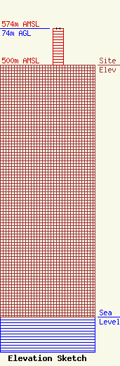
Site Elevation: 500 meters (1640 ft) |
| Height of Structure: 73 meters (240 feet) |
| Overall Height Above Ground: 74 meters (243 feet) |
| Overall Height Above Mean Sea Level: 574 meters (1883 feet) |
| Owner Info | Heartland Communications Group, LLC
4650 West Spencer Street
Appleton, WI 54914
(920) 882-4750
|
