|
|
Antenna Structure Registration 1051212 |
 |
Registration Info | Registration Number: 1051212 |
| File Number: A1383397 |
| FAA Study: 2021-ASW-7923-OE |
| FAA Issue Date: 06/09/2021 |
| Status: Constructed |
| Date Constructed: 02/25/2012 |
| NEPA: N |
Structure Info
| Structure Type: GTOWER |
| Structure Coordinates: 29-31-26.2 N 98-43-26.5 W (NAD 83) |
| Structure Coordinates: 29-31-25.4 N 98-43-25.4 W (Converted to NAD 27) |
| Structure Address: 11714 Galm Road, 5 Miles South (#210089) |
| Structure City: Helotes, TX |
| Structure County: Bexar County |
| Painting & Lighting Info |
FAA Circular #: 70/7460-1M |
FAA Chapters: 4, 9, 15 |
Remarks: PRIOR STUDY 2012-ASW-4096-OE |
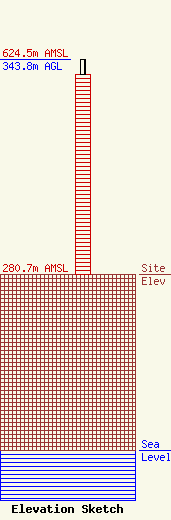
| Elevation Info |
Site Elevation: 280.7 meters (921 ft) |
| Height of Structure: 320.9 meters (1053 feet) |
| Overall Height Above Ground: 343.8 meters (1128 feet) |
| Overall Height Above Mean Sea Level: 624.5 meters (2049 feet) |
| Owner Info | American Towers LLC
10 Presidential Way
Woburn, MA 01801
(781) 926-4500
faa-fcc@americantower.com |
| Contact Info | American Towers LLC
10 Presidential Way
Woburn, MA 01801
(781) 926-4500
faa-fcc@americantower.com |
