|
|
Antenna Structure Registration 1051569 |
 |
Registration Info | Registration Number: 1051569 |
| File Number: A1339270 |
| FAA Study: 98-AGL-2217-OE |
| FAA Issue Date: 06/09/1998 |
| Status: Dismantled |
| Date Constructed: 08/15/1956 |
| FAA EMI: N |
| NEPA: N |
Structure Info
|
| Structure Coordinates: 47-10-49.0 N 97-3-35.0 W (NAD 83) |
| Structure Coordinates: 47-10-49.1 N 97-03-33.7 W (Converted to NAD 27) |
| Structure Address: 2 Mi N & 4.5 Mi W |
| Structure City: Gardner, ND |
| Structure County: Cass County |
| Painting & Lighting Info |
FCC Paragraph(s): 1, 3, 11, 21 |
Remarks: OM&L TO REMAIN PAINT/RED LIGHTS. |
| Elevation Info |
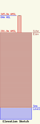
Site Elevation: 281.9 meters (925 ft) |
| Height of Structure: 64 meters (210 feet) |
| Overall Height Above Ground: 64 meters (210 feet) |
| Overall Height Above Mean Sea Level: 346 meters (1135 feet) |
| Owner Info | Gray Local Media, Inc.
4370 Peachtree Road, NE
Atlanta, GA 30319
(404) 266-8333
legalnotices@graymedia.com |
| Contact Info | Gray Local Media, Inc.
4370 Peachtree Road NE
Atlanta, GA 30319
Engineering Department
(404) 266-8333
legalnotices@graymedia.com |
