|
|
Antenna Structure Registration 1051747 |
 |
Registration Info | Registration Number: 1051747 |
| File Number: A0334389 |
| FAA Study: 99-ASW-1454-OE |
| FAA Issue Date: 04/26/1999 |
| Status: Constructed |
| Date Constructed: 01/01/1964 |
| FAA EMI: N |
| NEPA: N |
Structure Info
| Structure Type: 4TA2 |
| Structure Coordinates: 30-14-15.0 N 97-37-49.0 W (NAD 83) |
| Structure Coordinates: 30-14-14.2 N 97-37-48.0 W (Converted to NAD 27) |
| Structure Address: Twr 2 - 2600 Fm 973 |
| Structure City: Austin, TX |
| Structure County: Travis County |
| Painting & Lighting Info |
FAA Chapters: NONE |
Remarks: PRIOR FAA 98-ASW-3626-OE |
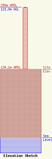
| Elevation Info |
Site Elevation: 134.1 meters (440 ft) |
| Height of Structure: 121 meters (397 feet) |
| Overall Height Above Ground: 121.9 meters (400 feet) |
| Overall Height Above Mean Sea Level: 256 meters (840 feet) |
| Owner Info | Emmis Austin Radio Broadcasting Company, L.P.
40 Monument Circle, Suite 700
Indianapolis, IN 46204
(317) 266-0100
KNorthern@emmis.com |
| Contact Info | Wiley Rein & Fielding LLP
1776 K Street, NW
Washington, DC 20006
John Fiorini
(202) 719-7145
jfiorini@wrf.com |
