|
|
Antenna Structure Registration 1051851 |
 |
Registration Info | Registration Number: 1051851 |
| File Number: A0061103 |
| FAA Study: 91-ASO-1045-OE |
| Status: Terminated |
| Date Constructed: 05/20/1992 |
| NEPA: N |
Structure Info
| Structure Type: TOWER |
| Structure Coordinates: 32-46-26.0 N 83-38-15.0 W (NAD 83) |
| Structure Coordinates: 32-46-25.5 N 83-38-15.3 W (Converted to NAD 27) |
| Structure Address: 4915 Old Gaul City Road |
| Structure City: Macon, GA |
| Structure County: Bibb County |
| Painting & Lighting Info |
FAA Circular #: 70/7460-1H |
FAA Chapters: 3, 4, 5, 13 |
| Elevation Info |
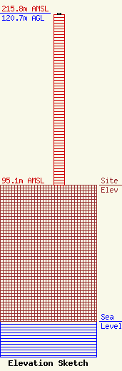
Site Elevation: 95.1 meters (312 ft) |
| Height of Structure: 119.8 meters (393 feet) |
| Overall Height Above Ground: 120.7 meters (396 feet) |
| Overall Height Above Mean Sea Level: 215.8 meters (708 feet) |
| Owner Info | U S BROADCASTING LIMITED PARTNERSHIP DBA = WMKS-FM
544 MULBERRY STREET
P.O. BOX 900
MACON, GA 31202-0900
(912) 746-6286
|
