|
|
Antenna Structure Registration 1051861 |
 |
Registration Info | Registration Number: 1051861 |
| File Number: A1327513 |
| Status: Constructed |
| Date Constructed: 01/28/1983 |
| FAA EMI: N |
| NEPA: N |
Structure Info
| Structure Type: TOWER |
| Structure Coordinates: 33-22-23.0 N 90-32-25.0 W (NAD 83) |
| Structure Coordinates: 33-22-22.6 N 90-32-24.7 W (Converted to NAD 27) |
| Structure Address: 2.3 Miles Ne |
| Structure City: Inverness, MS |
| Structure County: Sunflower County |
| Painting & Lighting Info |
FCC Paragraph(s): A1, B, G, H |
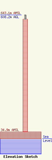
| Elevation Info |
Site Elevation: 34.9 meters (115 ft) |
| Height of Structure: 585.3 meters (1920 feet) |
| Overall Height Above Ground: 608.2 meters (1995 feet) |
| Overall Height Above Mean Sea Level: 643.1 meters (2110 feet) |
| Owner Info | Station RE Holdings LLC
3507
Jackson, MS 39207
(601) 360-9312
wcollums@aol.com |
| Contact Info | Baker & Hostetler LLP
1050 Connecticut Ave NW
Washington, DC 20036
Daniel Kirkpatrick
(202) 861-1758
dkirkpatrick@bakerlaw.com |
