|
|
Antenna Structure Registration 1051982 |
 |
Registration Info | Registration Number: 1051982 |
| File Number: A1185044 |
| Status: Constructed |
| Date Constructed: 01/01/1985 |
| FAA EMI: N |
| NEPA: N |
Structure Info
| Structure Type: 4TA1 |
| Structure Coordinates: 26-19-43.0 N 98-9-36.0 W (NAD 83) |
| Structure Coordinates: 26-19-41.7 N 98-09-35.0 W (Converted to NAD 27) |
| Structure Address: Twr 1 - 2921 N Closner |
| Structure City: Edinburg, TX |
| Structure County: Hidalgo County |
| Painting & Lighting Info |
FCC Paragraph(s): 1, 3, 11, 21 |
| Elevation Info |
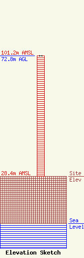
Site Elevation: 28.4 meters (93 ft) |
| Height of Structure: 72.8 meters (239 feet) |
| Overall Height Above Ground: 72.8 meters (239 feet) |
| Overall Height Above Mean Sea Level: 101.2 meters (332 feet) |
| Owner Info | Leading Media Group Corp.
5633 Richmond Avenue
Houston, TX 77057
(281) 974-4347
Israel.gutierrez@multimedios.com |
| Contact Info | Thompson Hine LLP
Suite 700
Washington, DC 20036
Barry Friedman
(202) 331-8800
barry.friedman@thompsonhine.com |
