|
|
Antenna Structure Registration 1052056 |
 |
Registration Info | Registration Number: 1052056 |
| File Number: A1199201 |
| FAA Study: 2015-AGL-4282-OE |
| FAA Issue Date: 04/17/2015 |
| Status: Constructed |
| Date Constructed: 08/19/2015 |
| NEPA: N |
Structure Info
| Structure Type: GTOWER |
| Structure Coordinates: 43-44-33.1 N 84-48-18.7 W (NAD 83) |
| Structure Coordinates: 43-44-33.0 N 84-48-18.6 W (Converted to NAD 27) |
| Structure Address: 7004 North Lincoln |
| Structure City: Clare, MI |
| Structure County: Isabella County |
| Painting & Lighting Info |
FAA Circular #: 70/7460-1K |
FAA Chapters: 3, 4, 5, 12 |
Remarks: PRIOR STUDY 2003-AGL-7220-OE. FAA CHAPTERS 3,4,5,12; 70/7460-1K WITH FAA APPROVED BIRD DEVIATION LIGHTING SPECIAL CONDITION. |
| Elevation Info |
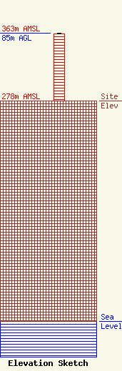
Site Elevation: 278 meters (912 ft) |
| Height of Structure: 84.1 meters (276 feet) |
| Overall Height Above Ground: 85 meters (279 feet) |
| Overall Height Above Mean Sea Level: 363 meters (1191 feet) |
| Owner Info | Black Diamond Broadcast Group, LLC
6016
Traverse City, MI 49696-6016
(231) 922-4981
nlmckee@blackdiamondbroadcasting.com |
| Contact Info | Black Diamond Broadcasting Group, LLC
6016
Traverse City, MI 49696-6016
(231) 922-4981
nlmckee@blackdiamondbroadcasting.com |
