|
|
Antenna Structure Registration 1052059 |
 |
Registration Info | Registration Number: 1052059 |
| File Number: A0685209 |
| FAA Study: 98-ASO-0748-OE |
| FAA Issue Date: 03/17/1998 |
| Status: Constructed |
| Date Constructed: 01/05/1995 |
| FAA EMI: N |
| NEPA: N |
Structure Info
| Structure Type: TOWER |
| Structure Coordinates: 18-16-38.0 N 65-51-13.0 W (NAD 83) |
| Structure Coordinates: 18-16-45.2 N 65-51-14.4 W (Converted to NAD 27) |
| Structure Address: 0.8 Km East Of State Road # 186 |
| Structure City: Cubuy, PR |
| Structure County: Can˘vanas Municipio |
| Painting & Lighting Info |
FAA Circular #: 70/7460-1J |
FAA Chapters: 3, 4, 5, 13 |
| Elevation Info |
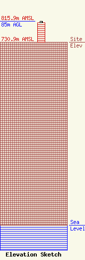
Site Elevation: 730.9 meters (2398 ft) |
| Height of Structure: 77.7 meters (255 feet) |
| Overall Height Above Ground: 85 meters (279 feet) |
| Overall Height Above Mean Sea Level: 815.9 meters (2677 feet) |
| Owner Info | AMERICA-CV STATION GROUP, INC.
13001 N.W. 107TH AVE.
HIALEAH GARDENS, FL 33018
(305) 592-4141
|
| Contact Info | Fletcher, Heald & Hildreth, PLC
1300 N 17th Street, 11th Floor
Arlington, VA 22209
Peter Tannenwald
(703) 812-0400
tannenwald@fhhlaw.com |
