|
|
Antenna Structure Registration 1052108 |
 |
Registration Info | Registration Number: 1052108 |
| File Number: A0897516 |
| FAA Study: 98-ASW-1901-OE |
| FAA Issue Date: 06/05/1998 |
| Status: Constructed |
| Date Constructed: 03/16/1965 |
| FAA EMI: N |
| NEPA: N |
Structure Info
| Structure Type: TOWER |
| Structure Coordinates: 32-47-38.0 N 104-12-31.0 W (NAD 83) |
| Structure Coordinates: 32-47-37.6 N 104-12-29.2 W (Converted to NAD 27) |
| Structure Address: Rt. 83, 19 Km. East |
| Structure City: Artesia, NM |
| Structure County: Eddy County |
| Painting & Lighting Info |
FCC Paragraph(s): 1, 3, 8, 17, 21 |
Remarks: RED LIGHTS/PAINT - REF. STUDY 96-ASW-3026-OE |
| Elevation Info |
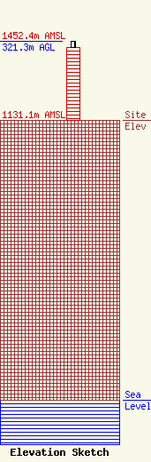
Site Elevation: 1131.1 meters (3711 ft) |
| Height of Structure: 294.6 meters (967 feet) |
| Overall Height Above Ground: 321.3 meters (1054 feet) |
| Overall Height Above Mean Sea Level: 1452.4 meters (4765 feet) |
| Owner Info | Pecos Valley Broadcasting Company
317 West Quay Avenue
Artesia, NM 88210
(575) 746-2751
gene.dow@pvbcradio.com |
| Contact Info | Cohn and Marks LLP
1920 N Street NW, Suite 300
Washington, DC 20036
Ronald Siegel
(202) 452-4827
ron.siegel@cohnmarks.com |
