|
|
Antenna Structure Registration 1052111 |
 |
Registration Info | Registration Number: 1052111 |
| File Number: A1383344 |
| FAA Study: 2026-ASO-7540-OE |
| FAA Issue Date: 04/24/2026 |
| Status: Constructed |
| Date Constructed: 04/01/1978 |
| NEPA: N |
Structure Info
| Structure Type: LTOWER |
| Structure Coordinates: 37-44-30.1 N 87-6-58.2 W (NAD 83) |
| Structure Coordinates: 37-44-29.9 N 87-06-58.2 W (Converted to NAD 27) |
| Structure Address: Livermore Road & Byers Road Ky-5023 |
| Structure City: Owensboro, KY |
| Structure County: Daviess County |
| Painting & Lighting Info |
FAA Circular #: 70/7460-1L |
FAA Chapters: 4, 8, 12 |
Remarks: OM&L to remain the same as prior studies = A MED-DUAL SYSTEM |
Remarks: PRIOR STUDIES 2016-ASO-2-OE / 2026-ASO-61-OE |
Remarks: OM&L to remain the same as prior studies = A MED-DUAL SYSTEM |
Remarks: PRIOR STUDIES 2016-ASO-2-OE / 2026-ASO-61-OE |
| Elevation Info |
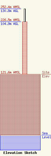
Site Elevation: 121.6 meters (399 ft) |
| Height of Structure: 104.9 meters (344 feet) |
| Overall Height Above Ground: 130.8 meters (429 feet) |
| Overall Height Above Mean Sea Level: 252.4 meters (828 feet) |
| Owner Info | VB-S1 Assets, LLC
22 W Atlantic Avenue
Delray Beach, FL 33444
(561) 406-4015
fcc-faa@verticalbridge.com |
| Contact Info | VB-S1 Assets, LLC
22 W Atlantic Avenue
Delray Beach, FL 33444
Richard Hickey
(561) 406-4015
fcc-faa@verticalbridge.com |
