|
|
Antenna Structure Registration 1052328 |
 |
Registration Info | Registration Number: 1052328 |
| File Number: A1050704 |
| FAA Study: 2006-AGL-2397-OE |
| FAA Issue Date: 05/18/2006 |
| Status: Constructed |
| Date Constructed: 02/27/2009 |
| FAA EMI: N |
| NEPA: N |
Structure Info
| Structure Type: TOWER |
| Structure Coordinates: 44-3-57.0 N 86-19-58.3 W (NAD 83) |
| Structure Coordinates: 44-03-57.0 N 86-19-58.0 W (Converted to NAD 27) |
| Structure Address: 3 Miles West Of Rt.31 |
| Structure City: Freesoil, MI |
| Structure County: Mason County |
| Painting & Lighting Info |
FAA Circular #: 70/7460-1K |
FAA Chapters: 3, 4, 5, 12 |
Remarks: PRIOR STUDY 1986-AGL-1644-OE |
| Elevation Info |
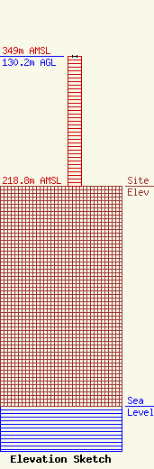
Site Elevation: 218.8 meters (718 ft) |
| Height of Structure: 130.2 meters (427 feet) |
| Overall Height Above Ground: 130.2 meters (427 feet) |
| Overall Height Above Mean Sea Level: 349 meters (1145 feet) |
| Owner Info | CMU Public Broadcasting
1999 East Campus Drive
Mt. Pleasant, MI 48859
(989) 774-3105
wayne.h@cmich.edu |
| Contact Info | CMU Public Broadcasting
1999 East Campus Drive
Mt. Pleasant, MI 48859
(989) 774-3105
wayne.h@cmich.edu |
