|
|
Antenna Structure Registration 1052455 |
 |
Registration Info | Registration Number: 1052455 |
| File Number: A0061768 |
| FAA Study: 98-ANM-0432-OE |
| FAA Issue Date: 09/28/1998 |
| Status: Constructed |
| Date Constructed: 04/19/1999 |
| NEPA: N |
Structure Info
| Structure Type: TOWER |
| Structure Coordinates: 38-18-54.0 N 105-12-42.0 W (NAD 83) |
| Structure Coordinates: 38-18-54.0 N 105-12-40.0 W (Converted to NAD 27) |
| Structure Address: Off Fremont County Rd 84, 9.7 Km S Of City |
| Structure City: Rockvale, CO |
| Structure County: Fremont County |
| Painting & Lighting Info |
FAA Circular #: 70/7460-1J |
FAA Chapters: 3, 4, 5, 13 |
Remarks: FAA ALSO APPROVED 4,8,13. |
Remarks: Removed expiration date from determination. Scenario 1./jjs/case#635066 |
| Elevation Info |
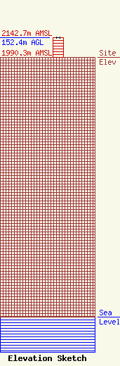
Site Elevation: 1990.3 meters (6530 ft) |
| Height of Structure: 151.5 meters (497 feet) |
| Overall Height Above Ground: 152.4 meters (500 feet) |
| Overall Height Above Mean Sea Level: 2142.7 meters (7030 feet) |
| Owner Info | KRLN, INC.
1615 CENTRAL AVENUE
CANON CITY, CO 81212-8578
(719) 275-7488
|
