|
|
Antenna Structure Registration 1052663 |
 |
Registration Info | Registration Number: 1052663 |
| File Number: A0973682 |
| FAA Study: 99-ANM-0276-OE |
| FAA Issue Date: 05/19/1999 |
| Status: Constructed |
| Date Constructed: 01/01/1980 |
| NEPA: N |
Structure Info
| Structure Type: POLE |
| Structure Coordinates: 47-19-12.0 N 119-34-26.0 W (NAD 83) |
| Structure Coordinates: 47-19-12.5 N 119-34-21.9 W (Converted to NAD 27) |
| Structure Address: 1 Mile West Of Ephrata On Beezley Hill |
| Structure City: Ephrata, WA |
| Structure County: Grant County |
| Painting & Lighting Info |
FAA Chapters: NONE |
Remarks: PRIOR FAA 98-ANM-0392-OE |
| Elevation Info |
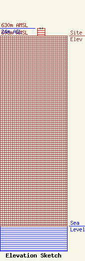
Site Elevation: 606 meters (1988 ft) |
| Height of Structure: 24 meters (79 feet) |
| Overall Height Above Ground: 24 meters (79 feet) |
| Overall Height Above Mean Sea Level: 630 meters (2067 feet) |
| Owner Info | TRMR, INC.
P.O. BOX 31000
SPOKANE, WA 99223
(509) 448-7400
ACN@ACN-NETWORK.COM |
