|
|
Antenna Structure Registration 1053118 |
 |
Registration Info | Registration Number: 1053118 |
| File Number: A1143378 |
| FAA Study: 96-AEA-0496-OE |
| FAA Issue Date: 07/31/1996 |
| Status: Constructed |
| Date Constructed: 01/01/1996 |
| FAA EMI: N |
| NEPA: N |
Structure Info
| Structure Type: TOWER |
| Structure Coordinates: 37-11-12.0 N 80-28-53.0 W (NAD 83) |
| Structure Coordinates: 37-11-11.5 N 80-28-53.8 W (Converted to NAD 27) |
| Structure Address: Price Mountain .45 Km Ese Of Stroubles Creek Rd |
| Structure City: Blacksburg, VA |
| Structure County: Montgomery County |
| Painting & Lighting Info |
FAA Chapters: NONE |
| Elevation Info |
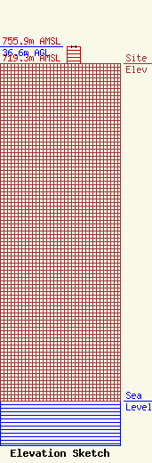
Site Elevation: 719.3 meters (2360 ft) |
| Height of Structure: 36.6 meters (120 feet) |
| Overall Height Above Ground: 36.6 meters (120 feet) |
| Overall Height Above Mean Sea Level: 755.9 meters (2480 feet) |
| Owner Info | Monticello Media LLC
149 Roscoe Blvd. South
Ponte Vedra Beach, FL 32082
(904) 285-3239
george@mediaservicesgroup.com |
| Contact Info | Monticello Media LLC
149 Roscoe Blvd. South
Ponte Vedra Beach, FL 32082
George Reed
(904) 285-3239
george@mediaservicesgroup.com |
