|
|
Antenna Structure Registration 1053162 |
 |
Registration Info | Registration Number: 1053162 |
| File Number: A0838426 |
| FAA Study: 83-ASW-172-OE |
| FAA Issue Date: 03/25/1983 |
| Status: Constructed |
| Date Constructed: 01/01/1984 |
| FAA EMI: N |
| NEPA: N |
Structure Info
| Structure Type: TOWER |
| Structure Coordinates: 33-25-45.0 N 94-7-12.0 W (NAD 83) |
| Structure Coordinates: 33-25-44.6 N 94-07-11.3 W (Converted to NAD 27) |
| Structure Address: .8 Km E Of Rt 989 @ Chaplewood Cemetary |
| Structure City: Texarkana, TX |
| Structure County: Bowie County |
| Painting & Lighting Info |
FCC Paragraph(s): 1, 3, 12, 21 |
Remarks: RED LIGHTS/PAINT |
| Elevation Info |
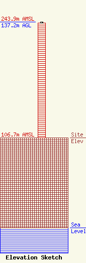
Site Elevation: 106.7 meters (350 ft) |
| Height of Structure: 136.2 meters (447 feet) |
| Overall Height Above Ground: 137.2 meters (450 feet) |
| Overall Height Above Mean Sea Level: 243.9 meters (800 feet) |
| Owner Info | Texarkana Radio Center Licenses, LLC
3161 Channel Drive
Juneau, AK 99801
(907) 586-3630
richard@abcstations.com |
| Contact Info | Davis Wright Tremaine LLP
1919 Pennsylvania Ave., N.W.
Washington, DC 20006-3401
(202) 973-4200
DavidSilverman@dwt.com |
