|
|
Antenna Structure Registration 1053329 |
 |
Registration Info | Registration Number: 1053329 |
| File Number: A1253756 |
| FAA Study: 2017-ASW-344-OE |
| FAA Issue Date: 03/10/2017 |
| Status: Constructed |
| Date Constructed: 04/17/2017 |
| NEPA: N |
Structure Info
| Structure Type: LTOWER |
| Structure Coordinates: 30-26-40.0 N 97-46-54.0 W (NAD 83) |
| Structure Coordinates: 30-26-39.3 N 97-46-53.0 W (Converted to NAD 27) |
| Structure Address: 12126 Roxie Dr |
| Structure City: Austin, TX |
| Structure County: Williamson County |
| Painting & Lighting Info |
FCC Paragraph(s): A2, H, 3, 4, 13, 21, 23 |
Remarks: PRIOR STUDY 1997-ASW-1151-OE |
Remarks: Continue As Is OM&L = A MED-DUAL SYSTEM |
Remarks: PRIOR STUDY 1997-ASW-1151-OE |
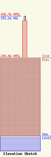
| Elevation Info |
Site Elevation: 284.6 meters (934 ft) |
| Height of Structure: 135.7 meters (445 feet) |
| Overall Height Above Ground: 152.1 meters (499 feet) |
| Overall Height Above Mean Sea Level: 436.7 meters (1433 feet) |
| Owner Info | K2 Towers III, LLC
57 E Washington St
Chagrin Falls, OH 44022
(440) 528-0333
rlepene@k2towers.com |
| Contact Info | K2 Towers III, LLC
57 E Washington St
Chagrin Falls, OH 44022
Greg Thompson
(440) 528-0333
gthompson@k2towers.com |
