|
|
Antenna Structure Registration 1053400 |
 |
Registration Info | Registration Number: 1053400 |
| File Number: A1261793 |
| FAA Study: 2022-ASW-6517-OE |
| FAA Issue Date: 01/13/2023 |
| Status: Constructed |
| Date Constructed: 10/08/2012 |
| NEPA: N |
Structure Info
| Structure Type: GTOWER |
| Structure Coordinates: 32-52-15.5 N 96-55-24.8 W (NAD 83) |
| Structure Coordinates: 32-52-15.0 N 96-55-23.8 W (Converted to NAD 27) |
| Structure Address: 1680 West Northwest Highway (30488) |
| Structure City: Dallas, TX |
| Structure County: Dallas County |
| Painting & Lighting Info |
FAA Circular #: 70/7460-1M |
FAA Chapters: 4, 8, 15 |
Remarks: OM&L to remain the same as prior studies = A MED-DUAL SYSTEM |
Remarks: PRIOR STUDIES 2013-ASW-2470-OE / 2022-ASW-2030-OE |
Remarks: OM&L to remain the same as prior studies = A MED-DUAL SYSTEM |
Remarks: PRIOR STUDIES 2013-ASW-2470-OE / 2022-ASW-2030-OE |
| Elevation Info |
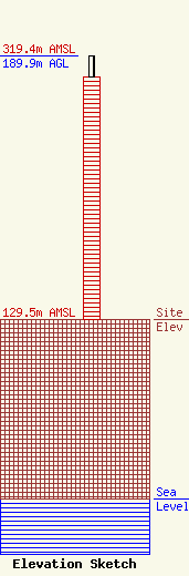
Site Elevation: 129.5 meters (425 ft) |
| Height of Structure: 175.3 meters (575 feet) |
| Overall Height Above Ground: 189.9 meters (623 feet) |
| Overall Height Above Mean Sea Level: 319.4 meters (1048 feet) |
| Owner Info | American Towers LLC
10 Presidential Way
Woburn, MA 01801
(781) 926-4500
faa-fcc@americantower.com |
| Contact Info | American Towers LLC
10 Presidential Way
Woburn, MA 01801
(781) 926-4500
faa-fcc@americantower.com |
