|
|
Antenna Structure Registration 1053411 |
 |
Registration Info | Registration Number: 1053411 |
| File Number: A1053602 |
| FAA Study: 98-ASO-6209-OE |
| FAA Issue Date: 09/28/1998 |
| Status: Constructed |
| Date Constructed: 01/01/1957 |
| FAA EMI: N |
| NEPA: N |
Structure Info
| Structure Type: TOWER |
| Structure Coordinates: 37-5-55.0 N 88-37-19.0 W (NAD 83) |
| Structure Coordinates: 37-05-54.8 N 88-37-18.8 W (Converted to NAD 27) |
| Structure Address: .22 Km N Of Int Of Us Business 54 And Ellis |
| Structure City: Paducah, KY |
| Structure County: McCracken County |
| Painting & Lighting Info |
FAA Circular #: 70/7460-1J |
FAA Chapters: 3, 4, 5, 13 |
| Elevation Info |
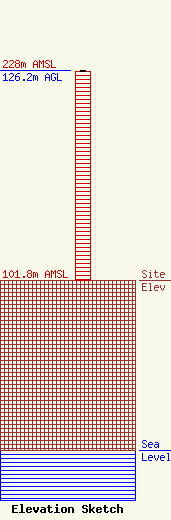
Site Elevation: 101.8 meters (334 ft) |
| Height of Structure: 125.3 meters (411 feet) |
| Overall Height Above Ground: 126.2 meters (414 feet) |
| Overall Height Above Mean Sea Level: 228 meters (748 feet) |
| Owner Info | Withers Broadcasting Company of Paducah, LLC
3501 BROADWAY STREET
MOUNT VERNON, IL 62864-1508
(618) 242-3500
drw@mvn.net |
| Contact Info | SCIARRINO & SHUBERT, PLLC
4601 N. FAIRFAX DRIVE
ARLINGTON, VA 22203
(202) 256-9551
DAWN@SCIARRINOLAW.COM |
