|
|
Antenna Structure Registration 1053688 |
 |
Registration Info | Registration Number: 1053688 |
| File Number: A1105300 |
| FAA Study: 91-ASW-2151-OE |
| FAA Issue Date: 02/11/1992 |
| Status: Constructed |
| Date Constructed: 05/01/1992 |
| FAA EMI: N |
| NEPA: N |
Structure Info
|
| Structure Coordinates: 32-54-4.0 N 96-41-15.0 W (NAD 83) |
| Structure Coordinates: 32-54-03.6 N 96-41-14.0 W (Converted to NAD 27) |
| Structure Address: 3710 Marquis Dr |
| Structure City: Garland, TX |
| Structure County: Dallas County |
| Painting & Lighting Info |
FCC Paragraph(s): B, C, H, 3, 4, 13, 21, 23 |
Remarks: DUAL HIGH INTENSITY |
| Elevation Info |
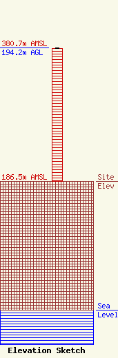
Site Elevation: 186.5 meters (612 ft) |
| Height of Structure: 193.2 meters (634 feet) |
| Overall Height Above Ground: 194.2 meters (637 feet) |
| Overall Height Above Mean Sea Level: 380.7 meters (1249 feet) |
| Owner Info | Iglesia Cristiana Ebenezer, Inc.
3207 Forest Ln.
Garland, TX 75042
(972) 840-9274
jipineda@msn.com |
| Contact Info | Iglesia Cristiana Ebenezer, Inc
3207 Forest Ln
Garland, TX 75042
Jose Pineda
(972) 840-9274
jipineda@msn.com |
