|
|
Antenna Structure Registration 1053966 |
 |
Registration Info | Registration Number: 1053966 |
| File Number: A0063475 |
| FAA Study: 82-ASW-1133-OE |
| FAA Issue Date: 07/02/1982 |
| Status: Constructed |
| Date Constructed: 01/01/1982 |
| NEPA: N |
Structure Info
| Structure Type: TOWER |
| Structure Coordinates: 33-23-34.0 N 94-14-45.0 W (NAD 83) |
| Structure Coordinates: 33-23-33.6 N 94-14-44.3 W (Converted to NAD 27) |
| Structure Address: 1000 Ft E Of Rt 991 .04 Mi Sw Of E Fork Rd |
| Structure City: Hooks, TX |
| Structure County: Bowie County |
| Painting & Lighting Info |
FCC Paragraph(s): 1, 3, 12, 21 |
Remarks: RED LIGHTS/PAINT |
| Elevation Info |
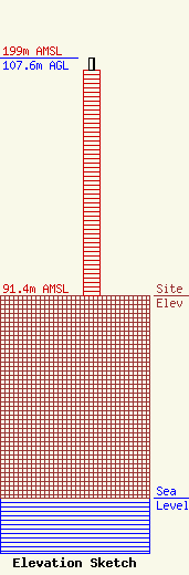
Site Elevation: 91.4 meters (300 ft) |
| Height of Structure: 102.1 meters (335 feet) |
| Overall Height Above Ground: 107.6 meters (353 feet) |
| Overall Height Above Mean Sea Level: 199 meters (653 feet) |
| Owner Info | TEXARKANA COLLEGE
2500 N ROBBISON RD
TEXARKANA, TX 75599
(903) 838-4541
SMITHCHEL@TC.CC.TX.US |
