|
|
Antenna Structure Registration 1054136 |
 |
Registration Info | Registration Number: 1054136 |
| File Number: A0063653 |
| FAA Study: 86-ASW-0660-OE |
| FAA Issue Date: 01/25/1986 |
| Status: Constructed |
| Date Constructed: 01/01/1998 |
| NEPA: N |
Structure Info
| Structure Type: BANT |
| Structure Coordinates: 29-44-57.0 N 95-28-56.0 W (NAD 83) |
| Structure Coordinates: 29-44-56.2 N 95-28-55.2 W (Converted to NAD 27) |
| Structure Address: 5847 San Felipe |
| Structure City: Houston, TX |
| Structure County: Harris County |
| Painting & Lighting Info |
FCC Paragraph(s): 3, 21 |
Remarks: RED LIGHTS ONLY |
| Elevation Info |
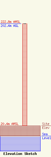
Site Elevation: 20.4 meters (67 ft) |
| Height of Structure: 202.4 meters (664 feet) |
| Overall Height Above Ground: 202.4 meters (664 feet) |
| Overall Height Above Mean Sea Level: 222.8 meters (731 feet) |
| Owner Info | SAN FELIPE PLAZA LTD. DBA = SAN FELIPE PLAZA
510 BERING, SUITE 500
HOUSTON, TX 77057
(713) 570-3052
SPECTRUM@CROWNCASTLE.COM |
