|
|
Antenna Structure Registration 1054150 |
 |
Registration Info | Registration Number: 1054150 |
| File Number: A1065635 |
| FAA Study: 2016-ASW-9879-OE |
| FAA Issue Date: 10/18/2016 |
| Status: Constructed |
| Date Constructed: 02/06/2017 |
| NEPA: N |
Structure Info
| Structure Type: GTOWER |
| Structure Coordinates: 32-35-7.0 N 96-58-7.0 W (NAD 83) |
| Structure Coordinates: 32-35-06.5 N 96-58-06.0 W (Converted to NAD 27) |
| Structure Address: 1200 W Beltline |
| Structure City: Cedar Hill, TX |
| Structure County: Dallas County |
| Painting & Lighting Info |
FAA Circular #: 70/7460-1J |
FAA Chapters: 4, 9, 13 |
Remarks: PRIOR STUDY 1998-ASW-2727-OE |
Remarks: OM&L to remain the same as prior study = A HIGH-DUAL SYSTEM |
Remarks: PRIOR STUDY 1998-ASW-2727-OE |
Remarks: OM&L to remain the same as prior study = A HIGH-DUAL SYSTEM |
| Elevation Info |
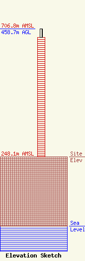
Site Elevation: 248.1 meters (814 ft) |
| Height of Structure: 427 meters (1401 feet) |
| Overall Height Above Ground: 458.7 meters (1505 feet) |
| Overall Height Above Mean Sea Level: 706.8 meters (2319 feet) |
| Owner Info | Telemundo of Texas LLC
c/o NBCUniversal
Washington, DC 20001
(202) 524-6401
margaret.tobey@nbcuni.com |
| Info |
