|
|
Antenna Structure Registration 1054285 |
 |
Registration Info | Registration Number: 1054285 |
| File Number: A1215499 |
| FAA Study: 99-AEA-0647-OE |
| FAA Issue Date: 04/18/1999 |
| Status: Constructed |
| Date Constructed: 01/19/1999 |
| FAA EMI: N |
| NEPA: N |
Structure Info
| Structure Type: TOWER |
| Structure Coordinates: 40-55-13.0 N 77-58-27.0 W (NAD 83) |
| Structure Coordinates: 40-55-12.8 N 77-58-28.0 W (Converted to NAD 27) |
| Structure Address: Off Route 504, 10.2 Miles West Of |
| Structure City: Bellefonte, PA |
| Structure County: Centre County |
| Painting & Lighting Info |
FAA Circular #: 70/7460-1J |
FAA Chapters: 4, 6, 13 |
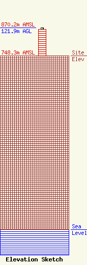
| Elevation Info |
Site Elevation: 748.3 meters (2455 ft) |
| Height of Structure: 115.8 meters (380 feet) |
| Overall Height Above Ground: 121.9 meters (400 feet) |
| Overall Height Above Mean Sea Level: 870.2 meters (2855 feet) |
| Owner Info | Pennsylvania, Commonwealth of
8001 Bretz Dr.
Harrisburg, PA 17112
(717) 787-8596
radio@pa.gov |
| Contact Info | Pennsylvania, Commonwealth of
8001 Bretz Dr.
Harrisburg, PA 17112
Benjamin Dorsey
(717) 425-5490
bedorsey@pa.gov |
