|
|
Antenna Structure Registration 1054372 |
 |
Registration Info | Registration Number: 1054372 |
| File Number: A0828396 |
| FAA Study: 94-ACE-0248-OE |
| FAA Issue Date: 09/16/1994 |
| Status: Constructed |
| Date Constructed: 06/30/1998 |
| FAA EMI: N |
| NEPA: N |
Structure Info
| Structure Type: TOWER |
| Structure Coordinates: 40-6-54.0 N 95-39-7.0 W (NAD 83) |
| Structure Coordinates: 40-06-54.0 N 95-39-06.0 W (Converted to NAD 27) |
| Structure Address: 1.7 Km Nw |
| Structure City: Straussville, NE |
| Structure County: Richardson County |
| Painting & Lighting Info |
FAA Circular #: 70/7460-1H |
FAA Chapters: 3, 4, 5, 13 |
| Elevation Info |
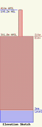
Site Elevation: 301.8 meters (990 ft) |
| Height of Structure: 107.3 meters (352 feet) |
| Overall Height Above Ground: 108.2 meters (355 feet) |
| Overall Height Above Mean Sea Level: 410 meters (1345 feet) |
| Owner Info | KNZA, Inc.
BOX 104
104
Hiawatha, KS 66434-0104
(785) 547-3461
knza@rainbowtel.net |
| Contact Info | Wilkinson Barker Knauer, LLP
2300 N Street, NW
Washington, DC 20037
(202) 783-4141
doxenford@wbklaw.com |
