|
|
Antenna Structure Registration 1054533 |
 |
Registration Info | Registration Number: 1054533 |
| File Number: A0064155 |
| FAA Study: 98-AGL-2118-OE |
| FAA Issue Date: 06/26/1998 |
| Status: Constructed |
| Date Constructed: 06/01/1964 |
| NEPA: N |
Structure Info
| Structure Type: 2TA2 |
| Structure Coordinates: 44-46-49.0 N 88-37-52.0 W (NAD 83) |
| Structure Coordinates: 44-46-49.1 N 88-37-51.6 W (Converted to NAD 27) |
| Structure Address: On Hwy. 29, 1.0 Mile West Of Western-most City Limits |
| Structure City: Shawano, WI |
| Structure County: Shawano County |
| Painting & Lighting Info |
FAA Circular #: |
FCC Paragraph(s): 1, 3, 12, 21 |
Remarks: RED LIGHTS/PAINT. |
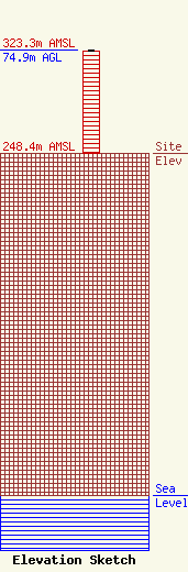
| Elevation Info |
Site Elevation: 248.4 meters (815 ft) |
| Height of Structure: 74.1 meters (243 feet) |
| Overall Height Above Ground: 74.9 meters (246 feet) |
| Overall Height Above Mean Sea Level: 323.3 meters (1061 feet) |
| Owner Info | GRASSMAN, BRUCE
1456 EAST GREEN BAY STREET
SHAWANO, WI 54166
(715) 524-2194
|
