|
|
Antenna Structure Registration 1054543 |
 |
Registration Info | Registration Number: 1054543 |
| File Number: A0064165 |
| FAA Study: 98-ASW-2470-OE |
| FAA Issue Date: 07/07/1998 |
| Status: Constructed |
| Date Constructed: 07/06/1990 |
| NEPA: N |
Structure Info
| Structure Type: TOWER |
| Structure Coordinates: 32-45-46.0 N 96-38-5.0 W (NAD 83) |
| Structure Coordinates: 32-45-45.5 N 96-38-04.0 W (Converted to NAD 27) |
| Structure Address: 2411 Memorial Drive |
| Structure City: Mesquite, TX |
| Structure County: Dallas County |
| Painting & Lighting Info |
FAA Circular #: |
FCC Paragraph(s): A1, B, C, H, 3, 4, 13, 21, 23 |
Remarks: DUAL HIGH INTENSITY LIGHTS. |
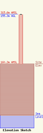
| Elevation Info |
Site Elevation: 160.3 meters (526 ft) |
| Height of Structure: 153.4 meters (503 feet) |
| Overall Height Above Ground: 155.3 meters (510 feet) |
| Overall Height Above Mean Sea Level: 315.6 meters (1035 feet) |
| Owner Info | MESQUITE INDEPENDENT SCHOOL DISTRICT
800 EAST KEARNEY
MESQUITE, TX 75149
(972) 882-7383
DENNIS@TENET.EDU |
