|
|
Antenna Structure Registration 1054567 |
 |
Registration Info | Registration Number: 1054567 |
| File Number: A1092918 |
| FAA Study: 97-AEA-3847-OE |
| FAA Issue Date: 02/07/1998 |
| Status: Constructed |
| Date Constructed: 08/25/1998 |
| FAA EMI: N |
| NEPA: N |
Structure Info
| Structure Type: TOWER |
| Structure Coordinates: 37-53-53.0 N 78-2-4.0 W (NAD 83) |
| Structure Coordinates: 37-53-52.5 N 78-02-05.0 W (Converted to NAD 27) |
| Structure Address: 5893 Parrish Rd. |
| Structure City: Louisia, VA |
| Structure County: Louisa County |
| Painting & Lighting Info |
FAA Circular #: 70/7460-1J |
FAA Chapters: 4, 8, 13 |
Remarks: Removed expiration date from determination. Scenario 1./jjs/case#635066 |
| Elevation Info |
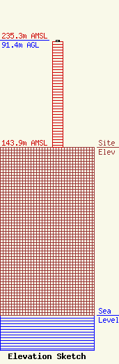
Site Elevation: 143.9 meters (472 ft) |
| Height of Structure: 90.5 meters (297 feet) |
| Overall Height Above Ground: 91.4 meters (300 feet) |
| Overall Height Above Mean Sea Level: 235.3 meters (772 feet) |
| Owner Info | Clearview Tower Company II, LLC
26 Yolanda Drive
Edison, NJ 08817
(732) 744-0652
smejia@clearviewtower.net |
| Contact Info | Clearview Tower Company II, LLC
26 Yolanda Drive
Edison, NJ 08817
Steven Mejia
(732) 744-0652
smejia@clearviewtower.net |
