|
|
Antenna Structure Registration 1054978 |
 |
Registration Info | Registration Number: 1054978 |
| File Number: A1149203 |
| FAA Study: 86-ASW-2613-OE |
| FAA Issue Date: 06/23/1987 |
| Status: Constructed |
| Date Constructed: 01/01/1986 |
| FAA EMI: N |
| NEPA: N |
Structure Info
| Structure Type: TOWER |
| Structure Coordinates: 34-30-43.0 N 97-58-5.0 W (NAD 83) |
| Structure Coordinates: 34-30-42.7 N 97-58-03.9 W (Converted to NAD 27) |
| Structure Address: 1701 W Pine |
| Structure City: Duncan, OK |
| Structure County: Stephens County |
| Painting & Lighting Info |
FAA Circular #: 70/7460-1G |
FAA Chapters: 3, 4, 5, 9 |
Remarks: RED LIGHTS/PAINT |
| Elevation Info |
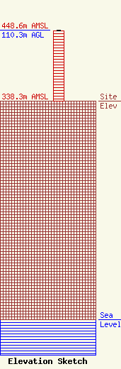
Site Elevation: 338.3 meters (1110 ft) |
| Height of Structure: 109.4 meters (359 feet) |
| Overall Height Above Ground: 110.3 meters (362 feet) |
| Overall Height Above Mean Sea Level: 448.7 meters (1472 feet) |
| Owner Info | Mollman Media, Inc.
627 W. Chickasha Ave.
Chickasha, OK 73018-7301
(405) 224-1560
matthew@mollmanmedia.com |
| Contact Info | Mollman Media, Inc.
627 W. Chickasha Ave.
Chickasha, OK 73018-7301
(405) 224-1560
matthew@mollmanmedia.com |
