|
|
Antenna Structure Registration 1055185 |
 |
Registration Info | Registration Number: 1055185 |
| File Number: A1342054 |
| FAA Study: 98-AGL-1386-OE |
| FAA Issue Date: 04/17/1998 |
| Status: Constructed |
| Date Constructed: 01/01/1982 |
| FAA EMI: N |
| NEPA: N |
Structure Info
| Structure Type: TOWER |
| Structure Coordinates: 43-33-11.0 N 83-41-28.0 W (NAD 83) |
| Structure Coordinates: 43-33-10.9 N 83-41-28.1 W (Converted to NAD 27) |
| Structure Address: 9750 Dutcher Rd |
| Structure City: Guilford Twp, MI |
| Structure County: Tuscola County |
| Painting & Lighting Info |
FCC Paragraph(s): A1, B, D, H |
Remarks: HIGH INTENSITY STROBES. |
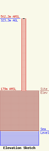
| Elevation Info |
Site Elevation: 179 meters (587 ft) |
| Height of Structure: 322.2 meters (1057 feet) |
| Overall Height Above Ground: 323.3 meters (1061 feet) |
| Overall Height Above Mean Sea Level: 502.3 meters (1648 feet) |
| Owner Info | VB Nimbus, LLC
22 W Atlantic Avenue
Delray Beach, FL 33444
(561) 406-4015
fcc-faa@verticalbridge.com |
| Contact Info | VB Nimbus, LLC
22 W Atlantic Avenue
Delray Beach, FL 33444
Richard Hickey
(561) 406-4015
fcc-faa@verticalbridge.com |
