|
|
Antenna Structure Registration 1055307 |
 |
Registration Info | Registration Number: 1055307 |
| File Number: A0977430 |
| FAA Study: 98-AWP-2509-OE |
| FAA Issue Date: 10/14/1998 |
| Status: Constructed |
| Date Constructed: 10/05/2000 |
| FAA EMI: N |
| NEPA: N |
Structure Info
| Structure Type: B |
| Structure Coordinates: 34-13-29.0 N 118-3-51.0 W (NAD 83) |
| Structure Coordinates: 34-13-29.0 N 118-03-47.8 W (Converted to NAD 27) |
| Structure Address: 15.63 Mi Ne Of Los Angeles |
| Structure City: Mount Wilson, CA |
| Structure County: Los Angeles County |
| Painting & Lighting Info |
FAA Chapters: NONE |
| Elevation Info |
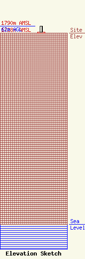
Site Elevation: 1728 meters (5669 ft) |
| Height of Structure: 8.5 meters (28 feet) |
| Overall Height Above Ground: 62 meters (203 feet) |
| Overall Height Above Mean Sea Level: 1790 meters (5873 feet) |
| Owner Info | Fox Television Stations, LLC
400 N. Capitol Street, NW
Washington, DC 20001
(202) 824-6522
jdiscipio@21cf.com |
| Contact Info | Fox Television Stations, LLC
400 N. Capitol Street, NW
Washington, DC 20001
(202) 824-6522
jdiscipio@21cf.com |
