|
|
Antenna Structure Registration 1055705 |
 |
Registration Info | Registration Number: 1055705 |
| File Number: A1381147 |
| Status: Constructed |
| Date Constructed: 01/01/1984 |
| FAA EMI: N |
| NEPA: N |
Structure Info
| Structure Type: TOWER |
| Structure Coordinates: 43-51-30.0 N 70-42-39.0 W (NAD 83) |
| Structure Coordinates: 43-51-29.7 N 70-42-40.8 W (Converted to NAD 27) |
| Structure Address: Tower Rd Winn Mt |
| Structure City: East Sebago, ME |
| Structure County: Cumberland County |
| Painting & Lighting Info |
FCC Paragraph(s): B, E, H |
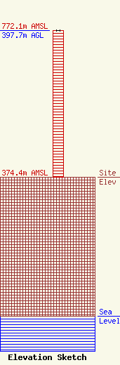
| Elevation Info |
Site Elevation: 374.4 meters (1228 ft) |
| Height of Structure: 397.7 meters (1305 feet) |
| Overall Height Above Ground: 397.7 meters (1305 feet) |
| Overall Height Above Mean Sea Level: 772.1 meters (2533 feet) |
| Owner Info | Pacific and Southern, LLC
8401 Greensboro Drive
McLean, VA 22102
(703) 873-6600
lawdept@tegna.com |
| Contact Info | TEGNA Inc.
8401 Greensboro Drive
McLean, VA 22102
Denise Branson
(703) 873-6606
dbranson@tegna.com |
