|
|
Antenna Structure Registration 1055898 |
 |
Registration Info | Registration Number: 1055898 |
| File Number: A0118364 |
| FAA Study: 98-ASO-7049-OE |
| FAA Issue Date: 11/24/1998 |
| Status: Constructed |
| Date Constructed: 04/01/1999 |
| FAA EMI: Y |
| NEPA: N |
Structure Info
| Structure Type: TOWER |
| Structure Coordinates: 33-31-30.0 N 90-9-52.0 W (NAD 83) |
| Structure Coordinates: 33-31-29.6 N 90-09-51.7 W (Converted to NAD 27) |
| Structure Address: Approx. 100 M Nw Of Intersection Roads Ione St. & Highland Ave. |
| Structure City: Greenwood, MS |
| Structure County: Leflore County |
| Painting & Lighting Info |
FAA Circular #: 70/7460-1J |
FAA Chapters: 3, 4, 5, 13 |
Remarks: PREV. 87-ASO-2229-OE |
| Elevation Info |
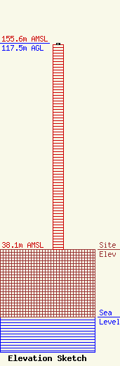
Site Elevation: 38.1 meters (125 ft) |
| Height of Structure: 116.6 meters (383 feet) |
| Overall Height Above Ground: 117.5 meters (385 feet) |
| Overall Height Above Mean Sea Level: 155.6 meters (510 feet) |
| Owner Info | HUGHES, RUBEN C
503 IONE STREET
GREENWOOD, MS 38390
(601) 453-1646
|
