|
|
Antenna Structure Registration 1055974 |
 |
Registration Info | Registration Number: 1055974 |
| File Number: A0500787 |
| FAA Study: N/A |
| Status: Constructed |
| Date Constructed: 04/01/1984 |
| FAA EMI: N |
| NEPA: N |
Structure Info
| Structure Type: TOWER |
| Structure Coordinates: 38-32-39.0 N 88-55-26.0 W (NAD 83) |
| Structure Coordinates: 38-32-38.8 N 88-55-25.8 W (Converted to NAD 27) |
| Structure Address: 4751 Cartter Rd |
| Structure City: Kell, IL |
| Structure County: Marion County |
| Painting & Lighting Info |
FCC Paragraph(s): A1, B, D, H |
| Elevation Info |
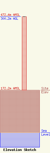
Site Elevation: 172.2 meters (565 ft) |
| Height of Structure: 300.2 meters (985 feet) |
| Overall Height Above Ground: 300.2 meters (985 feet) |
| Overall Height Above Mean Sea Level: 472.4 meters (1550 feet) |
| Owner Info | WPXS, Inc.
3901 Highway 121 South
Bedford, TX 76021
(817) 571-1229
Marcus.Lamb@daystar.com |
| Contact Info | Koerner & Olender, P.C.
11913 Grey Hollow Court
North Bethesda, MD 20852
Robert Olender
(301) 468-3336
Rolender.law@comcast.net |
