|
|
Antenna Structure Registration 1056094 |
 |
Registration Info | Registration Number: 1056094 |
| File Number: A1281556 |
| FAA Study: 2019-ANM-7690-OE |
| FAA Issue Date: 02/22/2021 |
| Status: Constructed |
| Date Constructed: 12/01/1998 |
| NEPA: N |
Structure Info
| Structure Type: LTOWER |
| Structure Coordinates: 47-30-16.3 N 121-58-10.0 W (NAD 83) |
| Structure Coordinates: 47-30-16.9 N 121-58-05.6 W (Converted to NAD 27) |
| Structure Address: 10812 279th Ave. So. East (7500) |
| Structure City: Issaquah, WA |
| Structure County: King County |
| Painting & Lighting Info |
FAA Circular #: 70/7460-1M |
FAA Chapters: 4, 8, 15 |
Remarks: PRIOR STUDY 2019-ANM-3452-OE |
| Elevation Info |
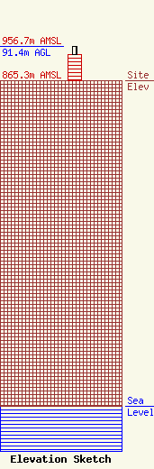
Site Elevation: 865.3 meters (2839 ft) |
| Height of Structure: 69.2 meters (227 feet) |
| Overall Height Above Ground: 91.4 meters (300 feet) |
| Overall Height Above Mean Sea Level: 956.7 meters (3139 feet) |
| Owner Info | American Towers LLC
10 Presidential Way
Woburn, MA 01801
(781) 926-4500
faa-fcc@americantower.com |
| Contact Info | American Towers LLC
10 Presidential Way
Woburn, MA 01801
(781) 926-4500
faa-fcc@americantower.com |
