|
|
Antenna Structure Registration 1056156 |
 |
Registration Info | Registration Number: 1056156 |
| File Number: A0066026 |
| FAA Study: 98-ASW-0923-OE |
| FAA Issue Date: 03/26/1998 |
| Status: Constructed |
| Date Constructed: 03/24/1974 |
| NEPA: N |
Structure Info
| Structure Type: BTWR |
| Structure Coordinates: 31-59-49.0 N 102-4-38.0 W (NAD 83) |
| Structure Coordinates: 31-59-48.6 N 102-04-36.5 W (Converted to NAD 27) |
| Structure Address: 303 W. Wall Street |
| Structure City: Midland, TX |
| Structure County: Midland County |
| Painting & Lighting Info |
FAA Circular #: 70/7460-1H |
FAA Chapters: 4, 5, 13 |
Remarks: REF STUDY #95-ASW-0026-OE |
Remarks: Removed expiration date from determination. Scenario 1./jjs/case#635066 |
| Elevation Info |
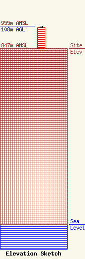
Site Elevation: 847 meters (2779 ft) |
| Height of Structure: 101 meters (331 feet) |
| Overall Height Above Ground: 108 meters (354 feet) |
| Overall Height Above Mean Sea Level: 955 meters (3133 feet) |
| Owner Info | PNRC PROPERTIES, LP
303 W. WALL STREET
P.O. BOX 3178
MIDLAND, TX 79702
(915) 683-4768
|
