|
|
Antenna Structure Registration 1056464 |
 |
Registration Info | Registration Number: 1056464 |
| File Number: A1197877 |
| FAA Study: 2021-ANM-4921-OE |
| FAA Issue Date: 07/26/2021 |
| Status: Constructed |
| Date Constructed: 01/01/1984 |
| NEPA: N |
Structure Info
| Structure Type: LTOWER |
| Structure Coordinates: 46-50-33.0 N 122-45-50.0 W (NAD 83) |
| Structure Coordinates: 46-50-33.6 N 122-45-45.5 W (Converted to NAD 27) |
| Structure Address: 5.5 Mi Ese |
| Structure City: Tenino, WA |
| Structure County: Thurston County |
| Painting & Lighting Info |
FAA Circular #: 70/7460-1K |
FAA Chapters: 4, 8, 12 |
Remarks: PRIOR STUDY 2001-ANM-3641-OE |
Remarks: OM&L to remain the same as prior study = A MED-DUAL SYSTEM |
Remarks: PRIOR STUDY 2001-ANM-3641-OE |
Remarks: OM&L to remain the same as prior study = A MED-DUAL SYSTEM |
| Elevation Info |
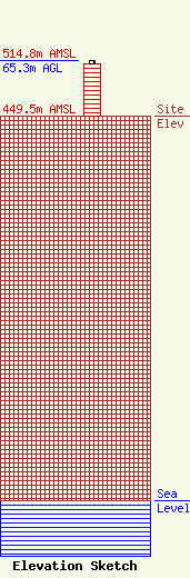
Site Elevation: 449.5 meters (1475 ft) |
| Height of Structure: 60.9 meters (200 feet) |
| Overall Height Above Ground: 65.3 meters (214 feet) |
| Overall Height Above Mean Sea Level: 514.8 meters (1689 feet) |
| Owner Info | THURSTON 9-1-1 COMMUNICATIONS
2703 PACIFIC AVENUE SE, SUITE A
OLYMPIA, WA 98501
(360) 704-2736
david.taylor@tcomm911.org |
| Contact Info | RADIO SERVICE SOLUTIONS
321
CORBETT, OR 97019-0321
(503) 912-7607
j.harrington@radioservicesolutions.com |
