|
|
Antenna Structure Registration 1056485 |
 |
Registration Info | Registration Number: 1056485 |
| File Number: A1350114 |
| FAA Study: 2017-ACE-2672-OE |
| FAA Issue Date: 07/09/2018 |
| Status: Constructed |
| Date Constructed: 08/22/2018 |
| NEPA: N |
Structure Info
| Structure Type: GTOWER |
| Structure Coordinates: 37-19-45.0 N 91-53-56.0 W (NAD 83) |
| Structure Coordinates: 37-19-44.8 N 91-53-55.4 W (Converted to NAD 27) |
| Structure Address: 3 Miles East Of Houston On Highway "b" |
| Structure City: Houston, MO |
| Structure County: Texas County |
| Painting & Lighting Info |
FCC Paragraph(s): 1, 3, 11, 21 |
Remarks: Continue As Is OM&L = PAINT/RED LIGHTS |
| Elevation Info |
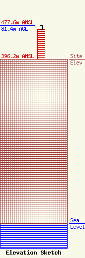
Site Elevation: 396.2 meters (1300 ft) |
| Height of Structure: 72.4 meters (238 feet) |
| Overall Height Above Ground: 81.4 meters (267 feet) |
| Overall Height Above Mean Sea Level: 477.6 meters (1567 feet) |
| Owner Info | MEDIA PROFESSIONAL, LLC
PO BOX 230
HOUSTON, MO 65483
(417) 260-0071
gsholtz@gmail.com |
| Contact Info | Media Professional LLC
PO BOX 230
HOUSTON, MO 65483
George Sholtz
(417) 260-0071
gsholtz@gmail.com |
