|
|
Antenna Structure Registration 1056944 |
 |
Registration Info | Registration Number: 1056944 |
| File Number: A1381022 |
| FAA Study: 98-ASW-2823-OE |
| FAA Issue Date: 09/24/1998 |
| Status: Constructed |
| Date Constructed: 04/27/1993 |
| NEPA: N |
Structure Info
| Structure Type: TOWER |
| Structure Coordinates: 31-54-37.0 N 102-13-54.0 W (NAD 83) |
| Structure Coordinates: 31-54-36.6 N 102-13-52.5 W (Converted to NAD 27) |
| Structure Address: 11320 Country Road #127 |
| Structure City: Midland, TX |
| Structure County: Midland County |
| Painting & Lighting Info |
FAA Chapters: None |
| Elevation Info |
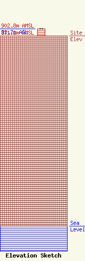
Site Elevation: 871.1 meters (2858 ft) |
| Height of Structure: 30.7 meters (101 feet) |
| Overall Height Above Ground: 31.7 meters (104 feet) |
| Overall Height Above Mean Sea Level: 902.8 meters (2962 feet) |
| Owner Info | KWES Television, LLC
8401 Greensboro Drive
McLean, VA 22102
(703) 873-6600
lawdept@tegna.com |
| Contact Info | TEGNA Inc.
8401 Greensboro Drive
McLean, VA 22102
Denise Branson
(703) 873-6606
dbranson@tegna.com |
