|
|
Antenna Structure Registration 1057874 |
 |
Registration Info | Registration Number: 1057874 |
| File Number: A0859093 |
| FAA Study: 2013-AEA-3672-OE |
| FAA Issue Date: 09/09/2013 |
| Status: Constructed |
| Date Constructed: 02/03/2006 |
| FAA EMI: N |
| NEPA: N |
Structure Info
| Structure Type: GTOWER |
| Structure Coordinates: 36-48-31.8 N 76-30-11.3 W (NAD 83) |
| Structure Coordinates: 36-48-31.3 N 76-30-12.5 W (Converted to NAD 27) |
| Structure Address: 3702d Nansemond Parkway/btg-site Norfolk-2 #010152 |
| Structure City: Suffolk-23435, VA |
| Structure County: Suffolk city |
| Painting & Lighting Info |
FAA Circular #: 70/7460-1K |
FAA Chapters: 4, 9, 12 |
Remarks: PRIOR STUDY 2006-AEA-5367-OE OM&L DUAL RED HIGH INTENSITY WHITE. |
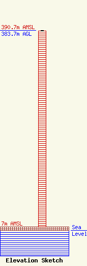
| Elevation Info |
Site Elevation: 7 meters (23 ft) |
| Height of Structure: 382.5 meters (1255 feet) |
| Overall Height Above Ground: 383.7 meters (1259 feet) |
| Overall Height Above Mean Sea Level: 390.7 meters (1282 feet) |
| Owner Info | American Towers LLC
10 Presidential Way
Woburn, MA 01801
(678) 564-3236
faa-fcc@americantower.com |
| Contact Info | American Towers, LLC.
10 Presidential Way
Woburn, MA 01801
(678) 564-3236
faa-fcc@americantower.com |
