|
|
Antenna Structure Registration 1057961 |
 |
Registration Info | Registration Number: 1057961 |
| File Number: A0131859 |
| FAA Study: 99-AGL-1430-OE |
| FAA Issue Date: 04/19/1999 |
| Status: Constructed |
| Date Constructed: 01/08/2000 |
| FAA EMI: N |
| NEPA: N |
Structure Info
| Structure Type: TOWER |
| Structure Coordinates: 38-26-2.0 N 89-18-55.0 W (NAD 83) |
| Structure Coordinates: 38-26-01.8 N 89-18-54.7 W (Converted to NAD 27) |
| Structure Address: East Side Of Aspen Rd 0.9 Km S Of Il Rt 177 |
| Structure City: Hoyleton, IL |
| Structure County: Washington County |
| Painting & Lighting Info |
FAA Circular #: 70/7460-1J |
FAA Chapters: 3, 4, 5, 13 |
Remarks: PREVIOUS FAA 98-AGL-4729-OE. |
Remarks: Removed expiration date from determination. Scenario 1./jjs/case#635066 |
| Elevation Info |
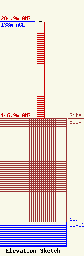
Site Elevation: 146.9 meters (482 ft) |
| Height of Structure: 137.1 meters (450 feet) |
| Overall Height Above Ground: 138 meters (453 feet) |
| Overall Height Above Mean Sea Level: 284.9 meters (935 feet) |
| Owner Info | WITHERS, DANA R DBA = RADIO STATION WNSV
818
BENTON, IL 62812
(618) 435-8100
|
