|
|
Antenna Structure Registration 1058385 |
 |
Registration Info | Registration Number: 1058385 |
| File Number: A1326145 |
| FAA Study: 98-ASW-1998-OE |
| FAA Issue Date: 05/21/1998 |
| Status: Constructed |
| Date Constructed: 01/05/1999 |
| FAA EMI: N |
| NEPA: N |
Structure Info
|
| Structure Coordinates: 32-23-10.0 N 95-6-44.0 W (NAD 83) |
| Structure Coordinates: 32-23-09.5 N 95-06-43.2 W (Converted to NAD 27) |
| Structure Address: Hwy 757--0.75km N. Of Int. Of Hwy 757 And 2767 |
| Structure City: Tyler, TX |
| Structure County: Smith County |
| Painting & Lighting Info |
FAA Circular #: 70/7460-1J |
FAA Chapters: 3, 4, 5, 13 |
| Elevation Info |
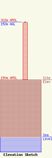
Site Elevation: 150 meters (492 ft) |
| Height of Structure: 151 meters (495 feet) |
| Overall Height Above Ground: 152 meters (499 feet) |
| Overall Height Above Mean Sea Level: 302 meters (991 feet) |
| Owner Info | S.O. 2,000 LC
212 Old Grande Boulevard
Tyler, TX 75703
(903) 581-5259
bspringer@reynoldsradio.com |
| Contact Info | S.O. 2,000, L.C.
212 Old Grande Boulevard
Tyler, TX 75703
Benny Springer
(903) 445-5187
bspringer@reynoldsradio.com |
