|
|
Antenna Structure Registration 1058614 |
 |
Registration Info | Registration Number: 1058614 |
| File Number: A1277233 |
| FAA Study: 2023-ASW-7466-OE |
| FAA Issue Date: 06/26/2023 |
| Status: Constructed |
| Date Constructed: 05/27/1998 |
Structure Info
| Structure Type: GTOWER |
| Structure Coordinates: 35-24-43.9 N 106-43-33.9 W (NAD 83) |
| Structure Coordinates: 35-24-43.8 N 106-43-31.8 W (Converted to NAD 27) |
| Structure Address: (#275054) From Site: 10 Km N068 To Santa Ana Pueblo |
| Structure City: San Ysidro, NM |
| Structure County: Sandoval County |
| Painting & Lighting Info |
FCC Paragraph(s): A1, B, D, H, 3, 6, 15, 21, 23 |
Remarks: Continue As Is OM&L = A HIGH-DUAL SYSTEM |
Remarks: PRIOR STUDY 2022-ASW-3854-OE |
Remarks: Continue As Is OM&L = A HIGH-DUAL SYSTEM |
Remarks: PRIOR STUDY 2022-ASW-3854-OE |
| Elevation Info |
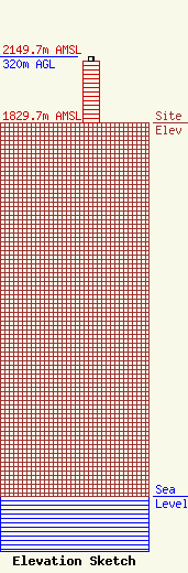
Site Elevation: 1829.7 meters (6003 ft) |
| Height of Structure: 298.7 meters (980 feet) |
| Overall Height Above Ground: 320 meters (1050 feet) |
| Overall Height Above Mean Sea Level: 2149.7 meters (7053 feet) |
| Owner Info | American Towers LLC
10 Presidential Way
Woburn, MA 01801
(781) 926-4500
faa-fcc@americantower.com |
| Contact Info | American Towers LLC
10 Presidential Way
Woburn, MA 01801
(781) 926-4500
faa-fcc@americantower.com |
