|
|
Antenna Structure Registration 1059012 |
 |
Registration Info | Registration Number: 1059012 |
| File Number: A1242844 |
| FAA Study: 2022-ASW-1150-OE |
| FAA Issue Date: 11/03/2022 |
| Status: Constructed |
| Date Constructed: 02/17/1999 |
| NEPA: N |
Structure Info
| Structure Type: LTOWER |
| Structure Coordinates: 34-47-32.5 N 92-28-40.1 W (NAD 83) |
| Structure Coordinates: 34-47-32.2 N 92-28-39.5 W (Converted to NAD 27) |
| Structure Address: 18401 Two Towers Rd (ar04944-a) |
| Structure City: Little Rock, AR |
| Structure County: Pulaski County |
| Painting & Lighting Info |
FAA Circular #: 70/7460-1J |
FAA Chapters: 4, 8, 13 |
Remarks: OM&L to remain the same as prior study = A MED-DUAL SYSTEM |
Remarks: PRIOR STUDY 1998-ASW-4264-OE |
Remarks: OM&L to remain the same as prior study = A MED-DUAL SYSTEM |
Remarks: PRIOR STUDY 1998-ASW-4264-OE |
| Elevation Info |
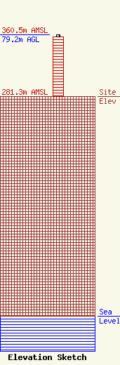
Site Elevation: 281.3 meters (923 ft) |
| Height of Structure: 76.2 meters (250 feet) |
| Overall Height Above Ground: 79.2 meters (260 feet) |
| Overall Height Above Mean Sea Level: 360.5 meters (1183 feet) |
| Owner Info | SBA Properties, LLC
8051 Congress Avenue
Boca Raton, FL 33487
(561) 995-7670
ERoach@sbasite.com |
| Contact Info | SBA Properties, LLC
8051 Congress Avenue
Boca Raton, FL 33487
(561) 995-7670
ERoach@sbasite.com |
