|
|
Antenna Structure Registration 1059185 |
 |
Registration Info | Registration Number: 1059185 |
| File Number: A1113867 |
| FAA Study: 2004-ASO-3230-OE |
| FAA Issue Date: 06/07/2004 |
| Status: Constructed |
| Date Constructed: 02/10/2005 |
| FAA EMI: N |
| NEPA: N |
Structure Info
| Structure Type: TOWER |
| Structure Coordinates: 34-22-19.9 N 82-10-3.9 W (NAD 83) |
| Structure Coordinates: 34-22-19.5 N 82-10-04.5 W (Converted to NAD 27) |
| Structure Address: 146 Tv Tower Road, Ware Shoals, Sc 29692. |
| Structure City: Ware Shoals, SC |
| Structure County: Laurens County |
| Painting & Lighting Info |
FAA Circular #: 70/7460-1J |
FAA Chapters: 3, 4, 5, 13 |
Remarks: PRIOR STUDY 1998-ASO-3421-OE |
Remarks: Removed expiration date from determination. Scenario 1./jjs/case#635066 |
Remarks: OM&L to remain the same as prior study = PAINT/RED LIGHTS |
Remarks: PRIOR STUDY 1998-ASO-3421-OE |
Remarks: Removed expiration date from determination. Scenario 1./jjs/case#635066 |
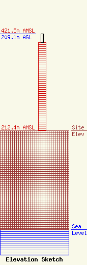
| Elevation Info |
Site Elevation: 212.4 meters (697 ft) |
| Height of Structure: 191.1 meters (627 feet) |
| Overall Height Above Ground: 209.1 meters (686 feet) |
| Overall Height Above Mean Sea Level: 421.5 meters (1383 feet) |
| Owner Info | South Carolina Educational TV Commission
1041 George Rogers Blvd
Columbia, SC 29201-4761
(803) 737-3500
mjahnke@scetv.org |
| Contact Info | SCETV
1041 George Rogers Blvd
Columbia, SC 29201-4761
Mark Jahnke
(803) 737-3500
mjahnke@scetv.org |
