|
|
Antenna Structure Registration 1059371 |
 |
Registration Info | Registration Number: 1059371 |
| File Number: A0069740 |
| FAA Study: 98-ANM-0937-OE |
| FAA Issue Date: 10/19/1998 |
| Status: Granted |
| NEPA: N |
Structure Info
| Structure Type: TOWER |
| Structure Coordinates: 46-42-11.0 N 122-57-17.0 W (NAD 83) |
| Structure Coordinates: 46-42-11.6 N 122-57-12.5 W (Converted to NAD 27) |
| Structure Address: 0.16 Km Ssw Of The Intersection Of Kresky Ave. And E Union St. |
| Structure City: Centralia, WA |
| Structure County: Lewis County |
| Painting & Lighting Info |
FAA Chapters: NONE |
| Elevation Info |
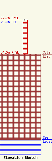
Site Elevation: 54.9 meters (180 ft) |
| Height of Structure: 22.3 meters (73 feet) |
| Overall Height Above Ground: 22.3 meters (73 feet) |
| Overall Height Above Mean Sea Level: 77.2 meters (253 feet) |
| Owner Info | PREMIER BROADCASTING, INC.
1133 KRESKY
CENTRALIA, WA 98531
(360) 736-1355
|
